The Maya ruled over a vast empire covering the modern-day states of southeast Mexico, Belize, Guatemala, portions of Honduras and El Salvador. The zenith of their rule eclipsed around 900 AD with the final remnants evaporating near 1500. Their understandings of astronomy, use of calendars, architecture, writing, sculpture, ceramics, and art were unparalleled in pre-Colombian America. In mathematics, their number base was 20 as opposed to our decimal 10 (they must have included their toes) and are one of only two civilizations to invent the concept of zero as a numeral (India being the other). They exist as a people to this day, with millions speaking Mayan as their first language and even living and worshiping (minus human sacrifice) as their ancestors did. Just as the U.S.A has plenty of Native American named cities and states: Peshtigo, Menominee, Oconto, Oklahoma, etc, so too, southeastern Mexico is loaded with Mayan named towns and states: Mahahual, Campeche, Xpuhil, Xiatil and so forth.
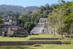
Within Mexico the states where Mayan ruins are most prevalent are Chiapas, Tabasco, Campeche, Yucatan, and Quintana Roo. The government has gone to great length to promote these ruins, creating a Maya World route throughout the area. Yesterday, I visited one of the most beautiful Mayan cities, Palenque. The unearthed and restored ruins today only represent less than 5 percent of the city that once covered over 2 ½ square kilometers and housed thousands. The most imposing structure is The Palace of Palenque with its unique central tower, the likes of which are found at no other Mayan ruin. In 1952, within the Temple of the Inscriptions a magnificent sarcophagus was discovered containing the remains of Palenque’s greatest ruler, Pacal. The sarcophagus, housed in the nearby Museo de Sitio, is enormous and adorned with intricate images of the ruler’s ancestors. So perfect is its condition, it looks as if it were carved only yesterday. The museum (entrance included in ruins fee) also contains other treasures unearthed within the burial chambers of the ruins: jade masks, large panels of glyphs, figurines, and one extremely worn limestone stela. Don’t pass on the museum. Placards are in both Spanish and English. I found it more fascinating than the ruins.
Palenque is a popular tourist destination with large air-conditioned buses purging their loads like busted piñatas. A small parking area around the main entrance has the usual vendors selling cheap junk along with beverages and fresh fruit. A group of guys wearing red Car Wash shirts hawk for business. I paid $3.79 to have the Tiger washed and when I returned from my walk of the ruins the bike was showroom perfect.
I checked out of my missile silo at El Panchan and pointed my compass east to the Caribbean Sea. Stopping for fuel, a local guy was checking out my bike. He invited me for lunch and I accepted. We walked a few feet to a taco stand where he treated me to two tacos and a soft drink. “Gracias, amigo!”
With my watch indicating 1:00 PM and over 300 miles to the sea, I needed to crank it up a notch. Riding northeast from Palenque, it’s not long before I enter the Yucatan Peninsula. Comprised of the Mexican states of Campeche, Yucatan and Quintana Roo the peninsula is an enormous table-flat limestone slab that once rested at the bottom of an ancient sea. Flocks of white birds flutter above tall marsh grasses interlaced with thin soiled land supporting a steamy tropical landscape of low shrubs and trees with cattle grazing the open range. The porous limestone is often undercut by percolating rain and underground rivers to form hundreds of freshwater sinkholes called cenotes. In some cases the limestone roofs covering the cenotes give way, creating huge open-air cylindrical wells falling off into the depths. Highways here are chalk line straight, flat and set at 62 MPH. It’s a boring ride through sparsely populated nothing but you can make good time here. But despite my speed and perseverance, it was soon 5:00 PM and it was clear I would not make it to the coast by nightfall. So I ended up in the small town of Xpujil, Campeche home to another Mayan ruin.
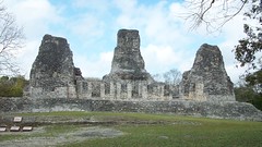
Early today I walked across the street from my hotel to see the Xpujil site, named after a type of cattail that grew around their principal water source. I’d only walked across the road and I’m already drenched with sweat. Damn it’s hot and humid here! As opposed to Palenque, here I only saw four other visitors. The main structure is called Building of the Three Towers and is 59 feet tall and 174 wide on a perfect north – south orientation. The most interesting aspect is a narrow entrance on the southeast corner of the left (south) tower. Here a shoulder wide steep stairway leads up through the stone structure to a lookout platform. The stairway ascends about 20 feet and has very narrow steps, no handholds and is perhaps at an angle of 55 degrees. Climbing up isn’t too bad but backing down is a bit intimidating. You do not want to fall down this bone crusher!
Departing Xpujil, I continue east and stop for lunch in the small resort town of Bacalar. On the western shore of the huge turquoise fresh water Bacalar Lagoon, Bacalar hosts wealthy Mexican families owning weekend getaway residences on the western shore of the lagoon. It’s also home to the Cenote Azul, the Yucatan’s largest cenote. Here I have my first Montejo beer. Brings back memories of my honeymoon on Cozumel.
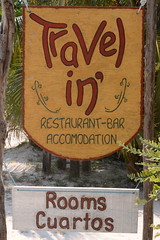
After lunch I press on to the cruise ship port of Mahahual studded with establishments like Señor Frog’s. Yuck! But I’m continuing south past the asphalt an additional 2 ½ miles down a limestone road with an occasional patch of soft sand blown from the sea only 50 feet to my left. I’m staying at the Travel in’ Hotel and Restaurant and will be here two nights. Run by Dutch nationals Justa and Albert, they’ve been here 12 years. They were hitchhiking across Mexico and decided this is the place to be. I have to admit it certainly feels off the grid complete with chickens scratching through the powdered white sand for delicacies, their eggs of which are part of the morning omelets.


Way cool! Thanks for the pics and historical background!