 The Ozarks are a land hidden in mystery and misconception. Mention you’re taking a trip to the Ozarks and many people may counter with “You mean the Ozark Mountains?” Well no, I don’t mean that at all. The Ozarks from a geological viewpoint are not mountains at all – and never were. The Ozarks are actually a high plateau, with the land pushed up about 25 million years ago and since eroded with deep wide valleys and hollows. Looking up from valley floors, the highland peaks may have the appearance of mountains but the forces responsible for true mountain building (volcanism and/or plate tectonics) never played a major role in building the regional plateaus.
Culturally isolated, the mainstream media has been largely responsible for stamping an unfavorable impression in most outsiders minds. Whether someone is from Appalachia or the Ozarks both are depicted with similar stereotypes. Mention Ozarkers and thoughts of moonshine, bad teeth, coon dogs, shotgun weddings, old Chevy pick-ups, and ignorant inbred hillbillies eating forest rodents shuffle across ones imagination. But boy, can they all play the banjo real good er what?!
National exposure was first brought about by the popular comic strip Li’l Abner which ran for 43 years and took place in the fictional town of Dogpatch, Kentucky. Next up, the situation comedy Beverly Hillbillies that ran for nine seasons. Although it’s not known exactly where the Clampets hailed from, the correlation to the Ozarks is evident. The country themed Petticoat Junction, Green Acres, and Hee Haw were also popular television programs during the 1970s.
During the same time the sitcoms were enjoying high ratings across America, a dark and menacing film was having a successful run in theatres. Enter Deliverance with its infamous Squeal!!! sodomitical scene. Somehow I doubt tourists flocked to the area once this movie was released.
In 2006 the respected best-selling author Daniel Woodrell (who actually resides in the Ozarks) wrote Winter’s Bone: a novel which delivers an additional punch to the face by adding xenophobia, methamphetamine labs, and murder to the growing list of reasons nobody in their right mind would ever venture into this snake pit.
Maybe my hero Anthony Bourdain can come to the rescue and shed some light. A 2011 episode of No Reservations has Tony hanging with his buddy Woodrell and it’s the only documentary I have ever found that had an opportunity to showcase this land to a national audience. And Tony failed miserably. The show opens with him dressing squirrels for a pot pie followed with the narrative claim “Nowhere was the Civil War worse, the fighting more fierce” than in the Ozarks. Jeez… more misinformation. Really, Tony? Pick up a history book before making such ludicrous statements. With all due respect to Ozarkers, none of the top ten bloodiest Civil War conflicts occurred in Missouri or Arkansas. He then ventures off into the night on a Current River spearing expedition for bottom feeders whereby Woodrell breaks his shoulder. Next night, sans Woodrell, the cameras go off into the woods with a bunch of guys that hunt raccoons “every night of the year.” I hope they misspoke as Missouri raccoon season only runs for 10 weeks. Later they all sit down to a coon dinner but it turns out most have never had the stuff! It’s as if this show went out of its way to just reinforce all the old tired, often repeated characteristics of Ozarkers. I’m a huge fan of Bourdain but I walked away learning nothing new. In order to gain a better understanding of the land and its history and people, I resorted to library books and college lectures on YouTube. Here’s a synopsis of what I learned.
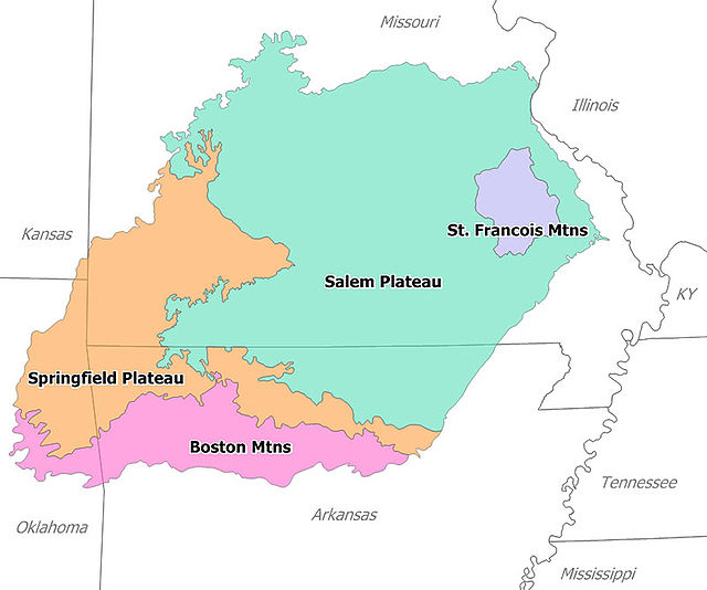
Ozarks Geographical Region
Geographically, unlike a county or state, the Ozarks do not have precise lines drawn on a map. Defining the boundary of the region is usually described in one of two ways: geologically or culturally. Most geologists today agree the Ozarks are confined to four states: Southern Missouri, northwest Arkansas, a portion of northeastern Oklahoma, and a fragment in Kansas. The footprint itself is further broken down into four distinct regions based on rock and soil composition. Two of the four regions use Mountains in their naming, but to reiterate an earlier point, neither are true mountains. With an area just over 46,000² miles, the land is slightly larger than the state of Ohio. Much of the terrain consists of soft sandstone and limestone, easily eroded by plentiful fresh water springs. The result is a karst topography dominated with caves. Within the United States, Missouri and Arkansas are ranked two and three respectively for number of known caves bowing only to Tennessee.
Historically the Ozarks have evidence of human activity that dates back over 10,000 years. The first written records of the area did not surface until the 1700s when the French made their way down the Mississippi to eastern Arkansas from Canada. It is believed the name Ozarks is the English pronunciation of a word derived from the French abbreviation aux Arcs (short for “of/at Arkansas”) which the French used in their correspondence to describe the land. At that time, the Osage were the most prevalent Native Americans and coexisted peacefully with the French. All that would change during the Trail of Tears with the Ozarks becoming a transitional point of the forced genocidal march west of Naive Americans with many settling in western Oklahoma. After the Native Americans left, the Ozarks were occupied by settlers of English, Scots-Irish and German decent. The Scots tended to be Protestant and settled more towards the center of the Ozarks while the Germans were Catholic and settled the fringes. Today a true cultural definition of an Ozarker is hard to come by but general traits usually include being Caucasian and Protestant which suggests that most Germans of the region may not associate themselves as being Ozarkers.
Over the last 150 years, the Ozarks have undergone great transformation. During the late 1800s, logging companies came and felled all the trees before moving west in the early 1900s. Stripped of trees, heavy erosion of the thin topsoil made farming that much more difficult or even impossible forcing locals to hunt and fish for sustenance. In 1908 Theodore Roosevelt established the Ozarks National Forest and later, in 1939, Franklin Roosevelt added the Mark Twain National Forest, placing a total of over 3,900² miles under federal management. During the Great Depression the Civilian Conservation Corps replanted millions of tress and today the land is once again heavily forested. Between 1911 and 1960 six massive reservoirs were formed by damning projects in the White River Basin of the southern Ozarks. Managed by the Army Corps of Engineers and created for the purpose of hydroelectric power and flood control these six lakes (Taneycomo, Sequoyah, Beaver, Table Rock, Bull Shoals, and Norfork) provide a huge draw for recreation. The northern Ozarks had four lakes (Lake of the Ozarks, Pomme de Terre, Stockton and Truman) formed in similar fashion. Contrary to the damning projects, a hard fought battle was won in 1972 to ensure the Buffalo River would remain free-flowing. Designated the first National River the Buffalo draws over 800,000 tourists annually for canoeing, fishing and hiking.
One of the most endearing traits of the Ozarks is presented through local bands performing in Branson, Missouri and Mountain View, Arkansas. Celtic music is the father of Bluegrass and is perhaps the greatest and most obvious link to the Old World. Sure, there are no bag pipes but folksy music has an unmistakable bond to Scots-Irish heritage. These are fun upbeat tunes: they don’t call it Pickin’ and Grinnin’ for nothing.
I Have Found a Way
I Have Found a Way © by Jacob Henry and Bill Jolliff. Released 2002.

Ozarks Travel Aids
I first gained interest in a trip to the Ozarks after I received a tweet from Motorcyclist Magazine. The tweet was highlighting the Tail of the Dragon in Tennessee but it also made mention of a road in Arkansas called the Pig Trail Scenic Byway: a nineteen mile section of Arkansas highway 23 running north from the town of Ozark. Further research indicated Arkansas is actively attempting to draw motorcyclists to their hilly winding roads, offering a free Arkansas Motorcycling Guide booklet showcasing 21 routes throughout the state many of which are in the Ozarks. That’s a welcome mat I can’t resist.
I plan to get immersed in Ozark country riding with four fellow Nomads on this trip. We’ll travel 1,800 miles over nine days with about 1,000 in the Ozarks. Weather permitting, we plan to camp half the nights hoping to enjoy scenic overlooks and clear running rivers from our camp sites. Other planned activities include a Civil War battle field tour at Pea Ridge, Arkansas, two cave tours, some bluegrass, a float down the Buffalo National River, and of course, hundreds of miles of fabulous motorcycling roads. The Nomad Budget for this adventure is $87 / day. Let the discovery begin.